Ledra Street
Nicosia, South Cyprus
 |
| Ledra Street |
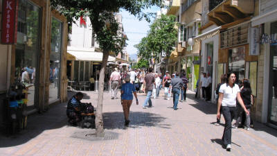
Ledra Street is a major, at one time the major, shopping street in Nicosia. It gets its name from the ancient kingdom of Ledra. In the 1950s, it was known as "Murder Mile", because of the activities of EOKA terrorists in the area.
In 1958, the road was split, and the first barricade erected dividing the Turkish and Greek Cypriots. After independence, the barricades were removed, only to be re-erected in 1964 as part of the Green Line.
The road is about 1 km in length. Some 800 metres lie on the Greek Cypriot side, about 150 metres on the Turkish Cypriot side (Where it is known as Lokmaci), and about 70 metres of no-mans land controlled by the United Nations.
In the south, there is a large variety of shops, ranging from department stores to small speciality shops selling arts and crafts. To the north, the street opens out into a maze of smaller streets, renowned for clothing and fruit.
Ledra Street has been pedestrianised since the 1990s as part of the Nicosia Master Plan, and will eventually link up with Kyrenia Avenue in the north to provide a north-south axis within the walled city. In 2008, this took a step closer with the opening of the Ledra/Lokmaci crossing point.
If you have children with you, a relaxing way to see the area is by the tourist train, which departs from Freedom Square at the south end of Ledra Street, and takes you along Ledra Street and the less well known (but equally pedestrianised) Onasagorou Street running parallel.
See the location in Google maps
Back to South Nicosia Index