The Venetian City Walls
Nicosia, Cyprus
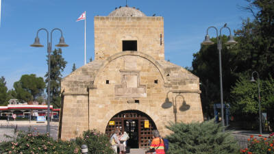 |
| Kyrenia Gate |
In 1567, the Venetians commissioned the Italian military engineers, Giulio Savorgnano and Franscesco Barbaro, to design new fortifications for the city of Nicosia, in order to protect the inhabitants from imminent Ottoman attack.
The new walls replaced the old-style medieval fortifications which engineers deemed inadequate to defend the city. The Venetians demolished several churches and palaces within the city as well as buildings lying outside the new walls, both for the acquisition of building materials and for a clearer field of vision for the defence of the city.
At the same time, the Pedieos River was diverted outside the city either in order to protect the residents from the flood or in order to flood the moat, which encircled the new walls.
This Venetian fortification complex has a circumference of 3 miles, and contains eleven pentagon-shaped bastions named after eleven families, pillars of the Italian aristocracy of the town, who donated funds towards the construction of the walls and the three gates, Porta San Domenico (Paphos Gate), Porta Guiliana (Famagusta Gate), and Porta del Proveditore (Kyrenia Gate).
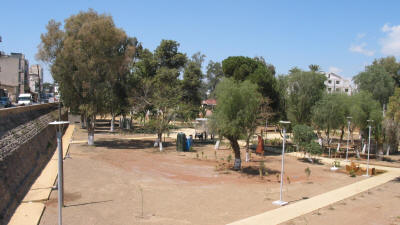 |
| Ankara Caglayan Park, Looking from the Cevizli Bastion |
Experts contemporary to the construction of the walls have considered them as a prime example of 16th century military architecture. Their design incorporates specific innovative techniques, marking the beginning of a renaissance era in fortification construction. These include the positioning of gates to the side of the adjoining bastions, so they could be more easily protected in times of siege, and leaving the upper half of the wall unlined with masonry, so as to increase its ability to absorb the impact from cannon shot.
Nonetheless, these fortifications were in vein, and the city fell to the forces of the Ottoman admiral, Lala Mustafa Pasha in 1570 before the Venetians had completed their construction. The Ottomans captured the bastions almost intact, and they remained almost unchanged till the British era.
Since 1996, each section of the walls - along with the three gates - has undergone restoration. During the restoration of the Podocataro bastion, fragments of cannons and other forms of weaponry were found, as well as ceramics, lead bullets, several coins, fragmentary Ottoman pipes and the stone foot of a large statue of a lion.
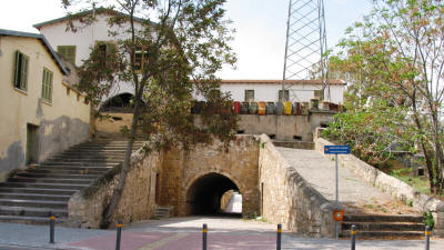 |
| Paphos Gate |
Of the eleven bastions, five are in the Turkish sector, five in the Greek, and one remains under the control of the United Nations. Starting at the 12 o'clock position, and working clockwise, the gates and bastions are as follows.
Kyrenia Gate. (Porta del Proveditore).
This was named after the military engineer, Proveditore Francesco
Barbaro. The
Kyrenia gate was an actual gate in the walls until 1931, when
the British built the road on either side of it.
Musalla (Barbaro) Bastion.
This bastion is occupied by the Turkish military forces. However it
houses the
National Struggle Museum, which is open to the public.
Cevizli (Loradano) Bastion.
The newly opened
Ankara Caglayan Park can be found in the moat area surrounding
this bastion.
Sibeli (Flatro) Bastion.
You will get no closer than a distant look here, as this bastion us
occupied by the United Nations. To continue with our circular tour,
you will have to divert to one of the two crossing points (Lokmaci
is closest), and come back along the green line.
Caraffa Bastion.
Pause here for the Melina Mercouri Hall.
Famagusta Gate (Porta Giuliani).
The gate, named after its designer Giulio Savorgnano, brother of
Ascanio, is probably the best preserved of the three gates. It is
now used as cultural centre.
Podocatro Bastion.
Here you will find the
Liberty Monument, and close by, a section of
aqueduct that brought the water supply from the mountains to the
city.
Constanza Bastion.
The
Bayraktor Mosque is located here.
D'Avila Bastion.
The Town hall is located on this bastion. Alongside, the road
through the wall, is known as
Freedom Square, or Plateia
Eleftherias. This is the traditional gathering point for Greek
Cypriots. The Tourist Information Centre is across the road from
here, in the
Laiki Geitonia pedestrian area.
Tripoli Bastion.
This bastion is used for car parking and as a bus station.
Paphos Gate (Porta San Domenico)
This gate is named after a Lusignan monastery near here, which the
Venetians demolished in 1567 to construct the walls. This is as far
as you go on the southern side, but before you go, have a look at
the Holy Cross Catholic Church. It is totally in no man's land, with
its front entrance on the Greek side, and its back (securely locked)
entrance on the Turkish side. To continue our journey, we need, once
more, to cross the Green Line. From here, the closest point is the
Ledra Palace.
Roccas Bastion.
We are once more in the Turkish area. The bastion has been made into
a park, and no man's land disappears. The walls themselves
do the job.
Zahra (Mula) Bastion.
As you journey to here, look down into the moat area. This is the
Green Line at its widest, and it comes complete with a UN
observation post (although seldom used nowadays).
Cephane (Quirni) Bastion.
This bastion houses the North Cyprus Presidential Palace, and marks
the end of our journey round the walls. Next stop, Kyrenia Gate.
See location in Google maps.
Back to Nicosia Index.